The Hidden Glasgow Forums
To post in the forums you will need to first register. All new members are welcomed, with one caveat: You must behave and be nice AND SEARCH BEFORE POSTING!
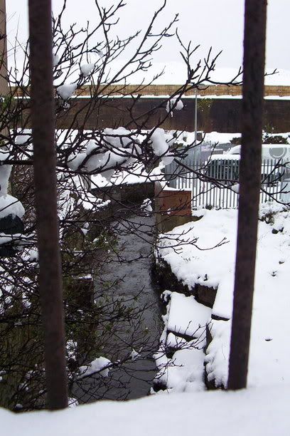
Molendinar Burn
Moderators: John, Sharon, Fossil, Lucky Poet, crusty_bint, Jazza, dazza


![]() by Apollo » Thu Mar 31, 2005 11:23 pm
by Apollo » Thu Mar 31, 2005 11:23 pm
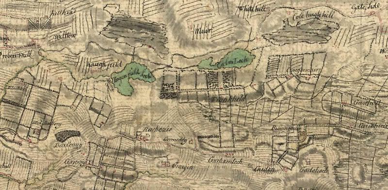
70s map shows Olgivie (not Ogilvie) Athletic Ground north of the loch, across the main road.
The little black pool just to the east is marked as a quarry beside Avenue End Rd.
The elliptical area in the upper right is Stepps Stadium.
The little black pool just to the east is marked as a quarry beside Avenue End Rd.
The elliptical area in the upper right is Stepps Stadium.
-

Apollo - Third Stripe

- Posts: 2283
- Joined: Sun May 09, 2004 10:26 pm
- Location: Glasgow

![]() by crusty_bint » Fri Apr 01, 2005 12:27 am
by crusty_bint » Fri Apr 01, 2005 12:27 am
Alchy, he pic is from the indispensible arial atlas of Glasgow, theres a link to it under books on the main page. I should have read through what u quoted more thoroughly, I never realised the cutting was older than the playing fields.
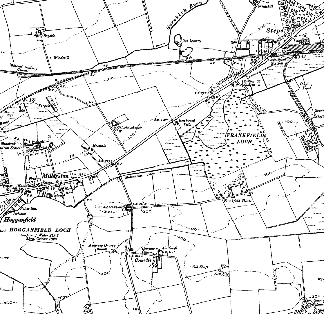
Here are links to three maps of the area in >1864<, >1899< and >1933< for your perusals, quite interesting in themselves (old maps are so nice to look at). Notice the evolution of Hogganfield Loch from its natural form to man-made bird sanctuary. Frankfield Loch also has a very engineered quality to it when u look at it, theres a lot of hard work gone into the straight edge and the cutting to Huggie. Obviously this has been to drain Cardowan Moss, what for I wonder though (agriculture, development, mining etc?) and when? Does anyone have access to an earlier map?
Some of you might find this site interestin (if you havnt already seen it) about the history of Stepps, I havnt read through it al but it does mention the Molendinar and the lochs a couple of times... its quite long tho... or thorough should I say? I'll shoosh noo... Heres the link :
:
http://www.skwebpages.com/stepps/origins.shtml
Crusty
Here are links to three maps of the area in >1864<, >1899< and >1933< for your perusals, quite interesting in themselves (old maps are so nice to look at). Notice the evolution of Hogganfield Loch from its natural form to man-made bird sanctuary. Frankfield Loch also has a very engineered quality to it when u look at it, theres a lot of hard work gone into the straight edge and the cutting to Huggie. Obviously this has been to drain Cardowan Moss, what for I wonder though (agriculture, development, mining etc?) and when? Does anyone have access to an earlier map?
Some of you might find this site interestin (if you havnt already seen it) about the history of Stepps, I havnt read through it al but it does mention the Molendinar and the lochs a couple of times... its quite long tho... or thorough should I say? I'll shoosh noo... Heres the link
http://www.skwebpages.com/stepps/origins.shtml
Crusty
here i go, it's coming for me through the trees
- crusty_bint
- -

- Posts: 4425
- Joined: Thu Jan 29, 2004 3:52 pm
- Location: Glasgow
![]() by crusty_bint » Mon Apr 04, 2005 9:19 am
by crusty_bint » Mon Apr 04, 2005 9:19 am
Taken from The Making of Scotland, Canongate Books
Good stuff Cptn, so it seems we have the cutting works narrowed down to a 30 year period if both the maps on the NLS site are accurate. I would like to get a hold of the afore-mentioned Roy survey of 1754 to see whats on that though, unfortunately its held in the British library and I found it difficult to make head-nor-tail of thier site... I think I have to be studying at an English University before they'll give access. Anywho, I wonder if the cutting was made to drain the turnpike rd later on, perhaps they encountered water management problems after its construction?
I'll keep reading though and see what else I can turn up.
Crusty
Robin Smith wrote:One looks in vain on Pont's map for the name stepps, which lies 7km north-east of Glasgow; the nearest road was at Cadder Kirk. William Roy's survey about 1754 showed no road in the area between Auchinloch and Provanmill, the most prominent feature being the shallow Colm Loch, later known as Frankfield loch. But a turnpike road was soon built, passing north of the loch to link Stirling with Glasgow (replacing the detour via Cadder Kirk and Kilsyth); it became Cumbernauld road.
Good stuff Cptn, so it seems we have the cutting works narrowed down to a 30 year period if both the maps on the NLS site are accurate. I would like to get a hold of the afore-mentioned Roy survey of 1754 to see whats on that though, unfortunately its held in the British library and I found it difficult to make head-nor-tail of thier site... I think I have to be studying at an English University before they'll give access. Anywho, I wonder if the cutting was made to drain the turnpike rd later on, perhaps they encountered water management problems after its construction?
I'll keep reading though and see what else I can turn up.
Crusty
here i go, it's coming for me through the trees
- crusty_bint
- -
- Posts: 4425
- Joined: Thu Jan 29, 2004 3:52 pm
- Location: Glasgow
![]() by crusty_bint » Wed Apr 06, 2005 3:28 pm
by crusty_bint » Wed Apr 06, 2005 3:28 pm
Okay, so I got Roys map:
There's certainly something happening but they look more like roads than water-ways?
There's certainly something happening but they look more like roads than water-ways?
here i go, it's coming for me through the trees
- crusty_bint
- -
- Posts: 4425
- Joined: Thu Jan 29, 2004 3:52 pm
- Location: Glasgow
![]() by Ronnie » Tue Mar 14, 2006 11:18 pm
by Ronnie » Tue Mar 14, 2006 11:18 pm
check out http://www.molendinar.com
I'd love to visit the underground chamber ... anyone know where the spiral staircase might be?
I'd love to visit the underground chamber ... anyone know where the spiral staircase might be?
upupdowndownleftrightleftrightbastart
-

Ronnie - Third Stripe
- Posts: 1983
- Joined: Sat Jan 17, 2004 11:22 pm
- Location: Glasgow

![]() by Ronnie » Tue Mar 14, 2006 11:54 pm
by Ronnie » Tue Mar 14, 2006 11:54 pm
red_kola wrote:Ronnie wrote:I'd love to visit the underground chamber ... anyone know where the spiral staircase might be?
Why don't you ask them?
Touché!
upupdowndownleftrightleftrightbastart
-
Ronnie - Third Stripe
- Posts: 1983
- Joined: Sat Jan 17, 2004 11:22 pm
- Location: Glasgow
![]() by weedgie_bored » Thu Mar 16, 2006 2:44 pm
by weedgie_bored » Thu Mar 16, 2006 2:44 pm
My child hood stamping ground, we used to fish for baggie minnies and sticklebacks in it.
Besides from where it ran under a road or railway it was largely unculverted and as I remember the route went, pre M8 of course.
From Huggie, under the road, through Pinkertons' rhubarb field to Riddrie Cemetery, where it used to form a pool (maybe still does) then ran to Provanmill Park (suppose that's now Molindinar Park) that's where the mill stood, the falls there formed another pool (where we used to swim 50's 60's) then through the whisky bond and the back of Blackhill between Acrehill St and the railway line, under Craigendmuir St and parallel to it then under the railway line, under the Provan Rd to run parallel to the Monkland Canal, between it and the gasworks, through the railway yard (the jungle) as far as what was Blochairn Steelworks where we could follow it no more.
Presume it cut through Dennistoun, under the Monkland, from there.
- weedgie_bored
- Busy bunny

- Posts: 26
- Joined: Sun Nov 13, 2005 1:20 pm
- Location: england
![]() by Shazbat » Thu Mar 16, 2006 3:32 pm
by Shazbat » Thu Mar 16, 2006 3:32 pm
Just checked out the 'Molendinar' site. Is it mibbe no just a wee story and the chamber doesn't really exist?
However, if it does, I'd be dead keen to explore.
However, if it does, I'd be dead keen to explore.
-

Shazbat - Second Stripe

- Posts: 230
- Joined: Sun May 22, 2005 10:18 am
- Location: Glasgow in body. Paisley in spirit.
![]() by Fat Cat » Thu Mar 16, 2006 3:42 pm
by Fat Cat » Thu Mar 16, 2006 3:42 pm
Alchemist wrote:Also in this vicinity were the lochs of Frankfield and Hogganfield, the two joined by an artificial cut, which was marked as "Molendinar Burn" on the Ordnance Survey maps, giving rise to a suggestion that the famous water course genuinely began at Frankfield. The late Jack House, in an article in the Glasgow Evening Citizen of 7th January 1946, dismissed this idea. He claimed that maps he had examined at the City Engineer's Department proved that Hogganfield Loch was the true source of the Molendinar. The Ordnance Survey Name Book of the 1850s described Frankfield as "Low, wet land, part in this [Cadder] parish & part in the Barony parish. This Loch is dry in summer & flooded in winter. There is not, at present, any sign of the ground being drained for cultivation". When the two lochs were frozen in winter, skaters could skate from one to the other along the "Molendinar" cut, although they had to break their momentum to cross the Avenue End Road.
I've looked at the OS map, can't see spit
Re Frankfield loch. I see yet another building company want to build houses over this. Pisses me off, yet another landmark disappearing under rows of lego houses.
-

Fat Cat - Third Stripe
- Posts: 840
- Joined: Wed Feb 09, 2005 3:09 pm
- Location: Glasgow
![]() by Ronnie » Fri Mar 17, 2006 1:34 am
by Ronnie » Fri Mar 17, 2006 1:34 am
Shazbat wrote:Just checked out the 'Molendinar' site. Is it mibbe no just a wee story and the chamber doesn't really exist?
Whatever gives you that idea?
upupdowndownleftrightleftrightbastart
-
Ronnie - Third Stripe
- Posts: 1983
- Joined: Sat Jan 17, 2004 11:22 pm
- Location: Glasgow
Return to Hidden Glasgow Projects
Who is online
Users browsing this forum: Google [Bot] and 70 guests