Thank god for the Electrical Interweb.
I'll set this out in four parts, the general history of the canal, the great disaster, the Canal then & now & the locations of interesting points along the route (photos throughout) If anyone can shed more light on the Port Eglinton or Johnstone parts, post up what you have, I could not find much without a visit to the Mitchell or Paisley Library & Museum (I'll save those trips for better weather) All comments / correction are most welcome. The short histories of the canal can be a bit repetitive, but each carries additional information & I wanted to keep the original sources clear.
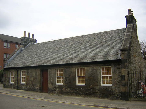
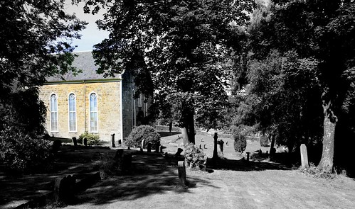
Eaglesham Estate
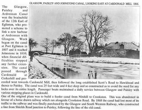
After seven centuries of ownership, the Montgomery family's finances floundered and Eaglesham Estate was put on the market in 1835. Hugh, 12th Earl of Eglinton promoted and partially funded theGlasgow, Paisley and Ardrossan Canal and Ardrossan Harbour projects. The Earl wanted to connect the booming industrial towns of Glasgow, Paisley and Johnstone to his new deep sea port at Ardrossan and his Ayrshire coal fields. However funds ran out and the canal was only constructed from Glasgow to Johnstone via Paisley.
http://www.geograph.org.uk/article/Eagl ... ed-Village
EGLINTON STREET
was originally called Marlborough Street, but at the opening of the Paisley and Johnstone Canal, of which concern the Earl of Eglinton was chairman, the name was changed.
http://www.glasgowguide.co.uk/info-gstreets3.html
The canal was laid out by the civil engineer Thomas Telford (1757-1834) and was to run thirty one and a quarter miles (50 Km) from Tradeston, Glasgow, to Ardrossan on the north Ayrshire coast through the counties of Renfrewshire and Ayrshire via Paisley, Johnstone, Dalry and Kilwinning. Thirty feet wide and four and a half feet deep, it would not only bring cargoes from the seaport at Ardrossan to Port Eglinton in Glasgow, but also attract trade from the coalfields along its length.
Although the money ran out at Johnstone, the completed part of the canal, opened in 1810, operated successfully for many years. The express passenger boats in 1836 carried 420,000 people between Paisley and Glasgow. It was finally made obsolete by the expansion of the railway system and in 1885 the channel was infilled. A railway now follows its path.
http://www.archiveshub.ac.uk/news/0703ardrossen.html
While the Caledonian Canal was in progress, Mr. Telford was
occupied in various works of a similar kind in England and Scotland
and also upon one in Sweden. In 1804, while on one of his journeys
to the north, he was requested by the Earl of Eglinton and others
to examine a project for making a canal from Glasgow to Saltcoats
and Ardrossan, on the north-western coast of the county of Ayr,
passing near the important manufacturing town of Paisley.
A new survey of the line was made, and the works were carried on during several successive years until a very fine capacious canal was completed, on the same level, as far as Paisley and Johnstown.
But the funds of the company falling short, the works were stopped,
and the canal was carried no further. Besides, the measures adopted by the Clyde Trustees to deepen the bed of that river and enable ships of large burden to pass up as high as Glasgow, had proved so successful that the ultimate extension of the canal to Ardrossan was no longer deemed necessary, and the prosecution of the work was accordingly abandoned.
But as Mr. Telford has observed, no person suspected, when the canal was laid out in 1805, "that steamboats would not only monopolise the trade of the Clyde, but penetrate into every creek where there is water to float them, in the British Isles and the continent of Europe, and be seen in every quarter of the world”
http://www.infomotions.com/etexts/guten ... frd10.html
January 1800 William Jessop, It was reported that he was employed to report on the scheme.
January 1800 John Rennie, He made a survey, plan and report on Saltcoats Harbour and gave his authority to the canal scheme.
October 1804 John Rennie, He reported on the route estimating that a canal for vessels of 25 tons would cost £130,960 or £166,711 if 60-ton vessels were to be used.
February 1805 Thomas Telford, He produced a report recommending a 32 mile canal from Tradeston to a new harbour to be built at Eglinton on Ardrossen Bay with a branch to Salcoats. There was to be an 18 mile summit and the total estimated cost was £134,500.
August 1805 Thomas Telford, A meeting in Paisley approved his plan and decided to apply for an Act of parliament.
January 1806 Authorised by the Glasgow, Paisley & Ardrossan Canal Act.
January 1811 Fully open.
January 1881 Closed.
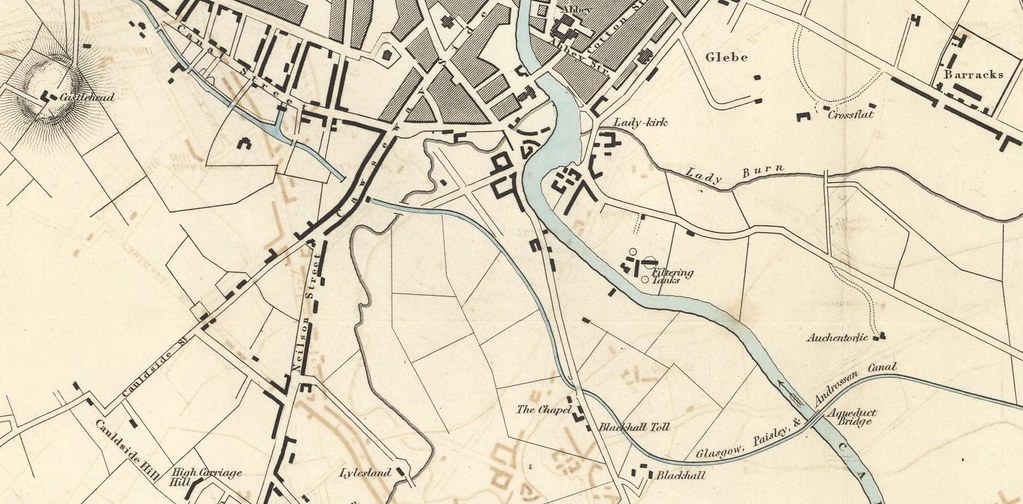
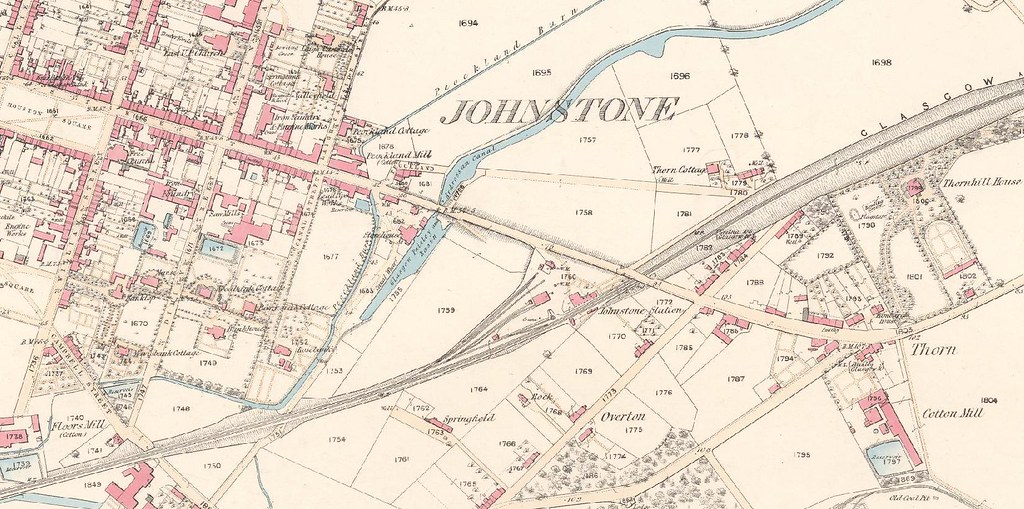
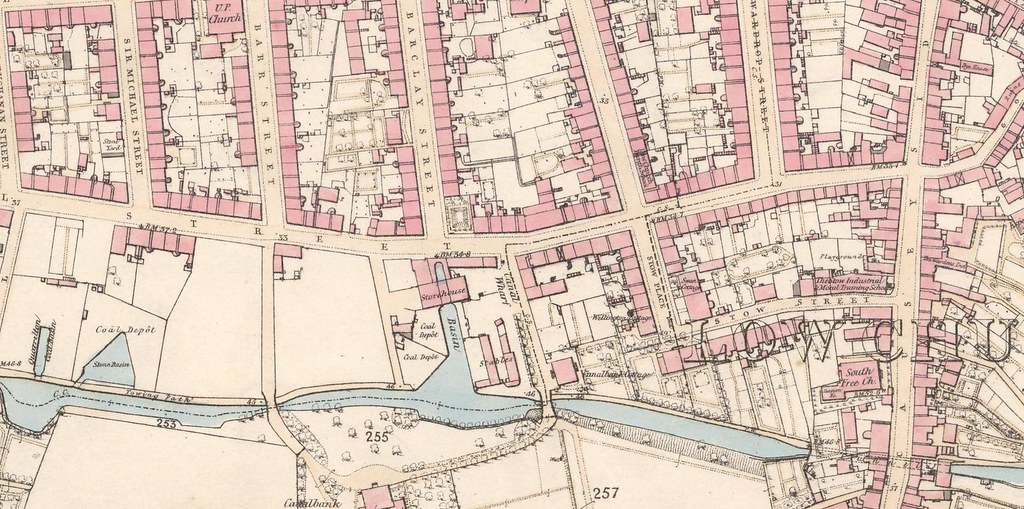
The canal started at Port Eglinton, just west of Eglinton Street in Glasgow. The end of the basin was beside Canal Street, which was renamed Mauchline Street in the 20th century. The canal meandered round Pollokshields and Dumbreck before passing through Paisley and further to Johnstone, where it terminated in the area of the present primary school, just north of Johnstone railway station.
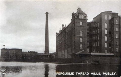
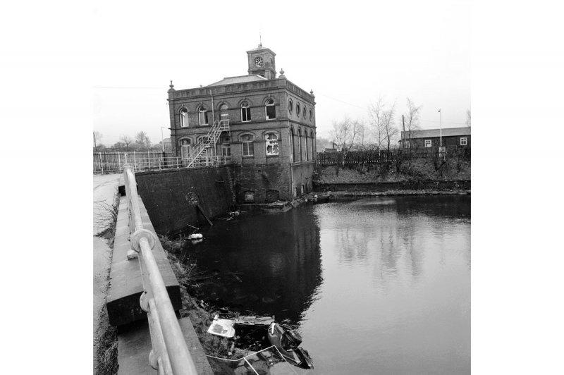
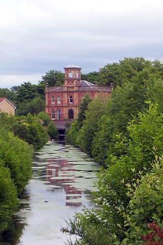
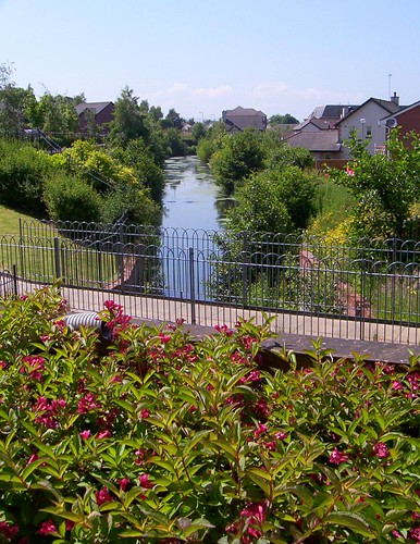
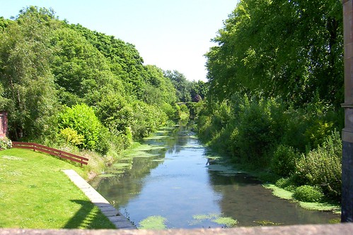
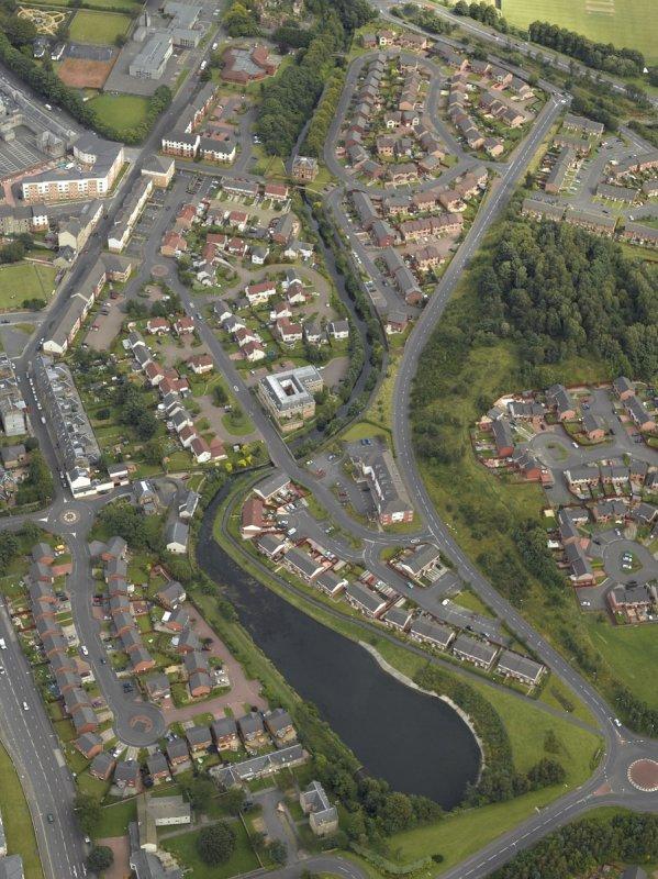
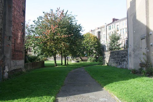
It was approximately eleven miles long and having followed the contours of the land was notable for having no locks. This made travelling the canal much quicker. There are few remains although there is a section of the canal in Paisley in an area of new housing that replaced Ferguslie Mills. This section seems to have been much changed by this development as pictures elsewhere show as it was when a working canal. Another section was reported in Linwood but reaearch of 19th Century maps revealed that this was in fact a lade built to supply water to a couple of mills.
When the Paisley Canal Railway line was constructed it was built on top of the canal from Glasgow to Paisley, although some of the tighter curves were smoothed out.
Between Paisley West and Elderslie, the line of the railway deviated slightly from the original line of the Glasgow, Paisley and Johnstone canal; a former loop in the canal was used to hold cooling water for the cotton thread mills at Ferguslie.
http://dictionary.sensagent.com/paisley ... ine/en-en/
Linwood Lade, as mentioned above:
http://picasaweb.google.co.uk/TheFoxSecS/LinwoodLade
The Paisley section:
http://picasaweb.google.co.uk/TheFoxSecS/PaisleySection
Glasgow, Paisley, and Ardrossan Canal.—The expense of land-carriage from Glasgow to the west coast through the fertile counties of Renfrew, and Ayr, abounding with coal and limestone, suggested a water conveyance. The operations on the canal commenced in May 1807, and the navigation opened between Glasgow and Johnstone on the 4th of October 1811. Although the canal was opened at that period, the trade did not commence till April 1812. The length of the canal from Port Eglinton to Ardrossan is 32½ miles, from Port Eglinton to Johnstone 11 miles, breadth at top 30 feet, at bottom 18. feet, and depth 4 feet 6 inches. There are no locks on that part of the canal yet executed, viz. between Port Eglinton and Johnstone; but when the canal is carried forward, there will be eight near Johnstone to raise the canal to the summit level, and thirteen to fall down to the harbour of Ardrossan. On the 6th of November 1810, passage-boats were put on this canal; but Mr William Houston, of Johnstone Castle, has the merit of introducing swift iron boats.
The great increase of passengers may be seen from the following statement.
‘The passengers did not all travel from Glasgow to Johnstone, many of them leaving at intermediate stages. During the months of July and August 1834, 50,000 persons took passages on the canal;—the number in one day was 2500. The proportions of the best cabin and second cabin passengers are, one-fifth of the best cabin passengers at one penny per mile, and four-fifths of second cabin passengers at three farthings per mile. The average total fare on the canal is therefore sixteen-twentieths of a penny per mile. The swift boats on the Forth and Clyde, and Union Canals, ply at similar rates.’
http://www.electricscotland.com/hiStory ... lasgow.htm
'Pictorial History of Paisley'. David Rowand. 1993
Little remains of the Glasgow, Paisley and Johnstone Canal, (originally named the Glasgow, Paisley and Ardrossan Canal) which extended for 11 miles (17 km) from Johnstone to Port Eglinton. Neither the Johnstone or Port Eglinton basins still exist; the former lay next to Canal Road, just northwest of Johnstone railway station while the latter lay close to Eglinton Street, a half-mile (1 km) south of Glasgow Bridge.
The canal transported a range of raw materials and finished good, such as coal, ironstone, bricks, slates timber, grain and textiles. Passenger traffic was also significant and novel express passenger boats were brought into service in 1830, pulled by six horses. This service carried up to 400,000 passengers each year and continued until the opening of the railways.
The canal was taken over by the Glasgow and South Western Railway Company in 1869 and was eventually closed by Act of Parliament in 1881. In that year a railway track was laid along the section between Glasgow and Paisley, a route now linking Glasgow Central to Paisley Canal station. The Blackhall Aqueduct survives as a railway bridge, but it is in the environs of the Ferguslie Thread Works in Paisley that the canal is best preserved.
http://www.geo.ed.ac.uk/scotgaz/feature ... t8803.html
A detailed background on the various costs of the Canal & Railway can be found here:
GLASGOW, PAISLEY, AND ARDROSSAN CANAL AND RAILWAY
http://www.jim-shead.com/waterways/sdoc ... 1#PNRCGP&J
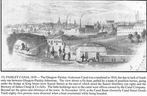
An engraving showing a passenger packet boat pulled by two horses with postillion riders near Paisley, on the Paisley Canal in 1849.

A closer look:

http://www.virtualwaterways.co.uk/New_a ... anals.html
A detailed description of the boats and their fares can be found here:
The Paisley Canal Passage Boats. By James Whitelaw. [From the London Mechanics' Magazine.]
http://books.google.com/books?id=YOc6AAAAMAAJ&pg=PA277
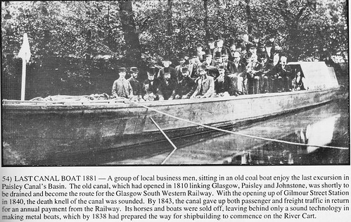
When the canal closes, the boats go south:
Mr. John Boulton, who had been brought up as a millwright, removed to Ashton in 1830, having obtained the management of the Flash Hall Mills there. His stay was brief, however, as in 1833 he was appointed to a more important post at Middleton. In 1835 he came again to Ashton as partner in Peter Platt & Co. In 1839 he took over the Egret Mills, but this enterprise ended in disaster and the loss of all his savings. In this dilemma Mr. John showed himself a man of initiative and energy. On the opening of the Sheffield, Ashton and Manchester Railway in 1841 it soon became evident that a considerable traffic must spring up between Ashton and Guide Bridge in connection with the new route and Mr.John succeeded in raising sufficient capital to put a number of horse-drawn passenger boats on the canal between those places, and this time his enterprise was rewarded with success. The packet- boats, as they were called, "went' and soon became prize ones. Later on Mr. John established a similar Service on the Peak Forest Canal between Dog Lane Station, Dukinfield, on the S.A. & M.R. and Marple and Macclesfield, a distance of some twenty miles, for which undertaking he purchased six or seven of the disused passenger boats of the Glasgow and Paisley Canal, then recently turned into a railway. These boats, which were 75ft. long and 6ft. 6in. beam, carried one hundred passengers and travelled at eight to ten miles an hour, made several trips a day. .
http://www.steamindex.com/people/boulton.htm
Methodism may have begun to flourish in Paisley from 1807 when English workmen came to build the canal.
http://www.arc-methodists.org.uk/paisle ... istory.pdf
Daniel Murray
I have a letter written from Tillicoultry on Nov. 20, 1849, by Daniel Murray to his brother Alexander -- my great, great, great grandfather -- who lived in Grenville Township, Quebec, Canada.
I am trying to determine the significance of the fact that Daniel was writing from Tillicoultry. As far as I know, this family of Murrays had no connection to Tillicoultry, but I could be quite wrong. Oral tradition holds that the family was descended from the Murrays of Atholl. The earliest information that I have is the birth of the first son of John Murray and Mary Cameron, named John, born 1787 in Camlachie, Glasgow. Their second son, Alexander, was born in Anderston, Glasgow, in 1788. John senior worked on various canals -- Crinan, Caledonian and Glasgow, Paisley & Johnstone -- as a labourer or possibly as a stonemason. Their family consisted of some eight sons and one or two daughters, with Daniel born in c.1801. From the letter it is clear that Daniel and his two sons were weavers and that the weaving trade was not prospering in 1849. I understand that Tillicoultry was a weaving centre in the 19th century, so this may explain why Daniel was there. I assume that weavers worked in their own homes at that time, hence my interest in the physical location of the return address. However, it is also interesting to note that one of the provosts of Tillicoultry was a Murray.
Daniel lived in Cairnton Street
I would be very grateful for any information or comments that you may have on the above.
Regards,
Cecil McPhee
Montreal, Canada
http://www.tillicoultry.org.uk/memory.htm
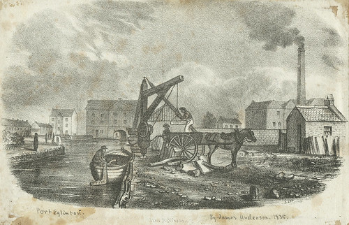
This drawing of 1835 depicts Port Eglinton in Tradeston, the terminus of the Glasgow, Paisley & Ardrossan Canal just west of Eglinton Street near Cumberland Street. Port Eglinton was named after the Earl of Eglinton.
The basin can be clearly seen under the words 'Port Eglinton'

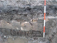
Port Eglinton was the terminus of the Glasgow-Paisley-Ardrossan Canal. Visible are the remains of the canal wharf wall running diagonally across the trench.
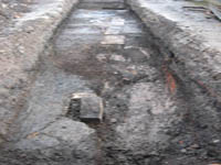
A detail from the base of the canal wall. It would appear that timber piles were driven into the ground and the stone wall was constructed on top of the piles.
http://www.transportscotland.gov.uk/pro ... t-eglinton
'Old Cardonald Had A Farm. John A. Innes. 1993
The bridge over the River Cart is the oldest railway bridge in the world still used by trains. It was built by Thomas Telford in 1810 and originally carried the Canal.
http://homepage.ntlworld.com/sealed/pai ... /canal.htm

'Old Cardonald Had A Farm'. John A. Innes. 1993
Blackhall Aqueduct:
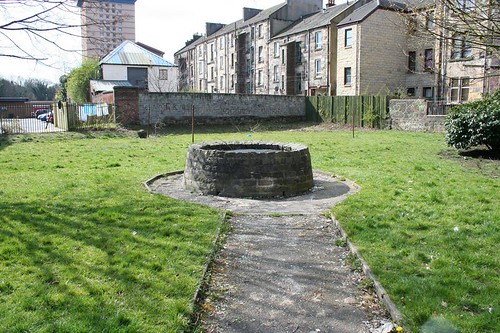
This is the only info I could find on the Johnstone end of the canal:
The canal was opened as far as this basin in October 1810. In 1820 stables were built in the vicinity at a cost of £120 and in 1832 a shed (NS46SW 193.15) was built for the gig-boat.
This terminal basin, in the SE corner of Johnstone, is clearly shown on the 1st edition of the OS 6-inch map (Renfrewshire 1863, sheet xi). The location of this basin is still visible on the 2nd edition of the OS 6-inch map (Renfrewshire 1898, sheet xiNE).
The location of the stables cannot be determined from the maps.
The agreement made between the Canal & Railway companies, June 1843:
http://victoria.cdlr.strath.ac.uk/_asse ... f/SBWQ.pdf


