Help placing 2 old photos (Scotstoun/Scotstounhill)

Moderators: John, Sharon, Fossil, Lucky Poet, crusty_bint, Jazza, dazza

Help placing 2 old photos (Scotstoun/Scotstounhill)

Postby Timchilli » Sat Jun 02, 2007 3:02 pm

Can anyone help me to place this view, which is only titled "Scotstoun West"? I think it may be a view of Dumbarton Road, with the railway to the right of view.

Image

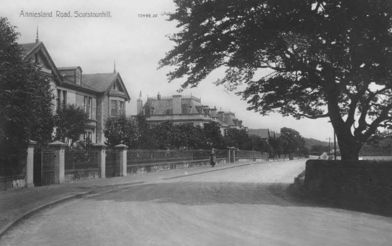
Also, this photo is captioned "Anniesland Road, Scotstounhill", but I can't figure out where exactly it was taken. Am I right in thinking that the 2 ornate villas between where the lady is walking have been pulled down, and this site is now Knightswood Shopping Centre?

Image

Any help would be greatly appreciated.

Tim
»»» Timelapse : Glasgow «««

»»» A History of Scotstoun ««« (UPDATED: 26 June 2007)
User avatar
Timchilli
Second Stripe
Second Stripe
 
Posts: 373
Joined: Fri May 21, 2004 4:28 pm
Location: Glasgow

Postby dmf » Sat Jun 02, 2007 6:33 pm

I think you are right with your second idea about Anniesland Road. Could your first photo be the junction of Dumbarton Road and Anniesland Road, where the Kingsway flats are now?


dmf
dmf
Busy bunny
Busy bunny
 
Posts: 25
Joined: Wed Apr 11, 2007 8:49 pm

Postby scaryman2u » Sat Jun 02, 2007 8:40 pm

It looks alot like Great Western Road.
User avatar
scaryman2u
Third Stripe
Third Stripe
 
Posts: 959
Joined: Sat Jun 24, 2006 2:22 pm
Location: GLASGOW

Postby HollowHorn » Sat Jun 02, 2007 9:18 pm

I agree with the 'Kingsway' theory.
User avatar
HollowHorn
Third Stripe
Third Stripe
 
Posts: 8921
Joined: Mon May 23, 2005 9:59 pm
Location: Paisley

Postby glasgowken » Sat Jun 02, 2007 9:20 pm

The tram is post 1904, and assuming the photo has been coloured accurately it's on a red service.
So I would also agree it's the junction of Dumbarton Road and Anniesland Road/Kingsway, the tram is on the service that would later become the 9.
GK
User avatar
glasgowken
Third Stripe
Third Stripe
 
Posts: 4477
Joined: Mon Oct 03, 2005 12:59 am
Location: Glasgow

Re: Help placing 2 old photos (Scotstoun/Scotstounhill)

Postby yokerboy » Wed Nov 20, 2013 1:14 pm

Anniesland Road: You are quite right to say that it is possible the the houses on the right were pulled down to make way for what is now Knightswood Shopping Centre,known local as the "Safeway" after the former suppermarket.

I remember as a you boy walking past these buildings on the right and even mucking around the derelicts. I can even recall running through the garden down to the railway at the bottom of them,obviously before the shopping centre was build. Some of the similar lovely houses still stand further along the rroad.
yokerboy
Just settling in
Just settling in
 
Posts: 5
Joined: Thu Nov 07, 2013 9:46 pm

Re: Help placing 2 old photos (Scotstoun/Scotstounhill)

Postby Vinny the Mackem » Thu Nov 21, 2013 12:54 pm

Image

Not really a great deal in this for reference point purposes, but the curve in the road in the foreground and, if you look closely, the road at the very far end (Not sure if that would still be Kingsway or Anniesland Road at that bit) would make sense of the Anniesland Road/Knightswood Shopping Centre location.

Google maps comparison

http://goo.gl/maps/Jk6Pt
User avatar
Vinny the Mackem
Second Stripe
Second Stripe
 
Posts: 399
Joined: Wed Mar 30, 2005 11:11 pm
Location: Glasgow

Re: Help placing 2 old photos (Scotstoun/Scotstounhill)

Postby Bridie » Thu Nov 21, 2013 10:02 pm

They must have demolished a lot of those houses. I remember playing in one of them in the last row left shortly after the shopping centre was built. The house was in a sorry state and all the kids would risk their necks running through it.

Wonder how old the trees are and if the one in the original picture is still there?
Yes HH,I know
User avatar
Bridie
Third Stripe
Third Stripe
 
Posts: 2267
Joined: Thu Jun 18, 2009 11:57 pm


Return to Glasgow Chat (Coffee Lounge)

Who is online

Users browsing this forum: No registered users and 28 guests