Page 4 of 5
Re: Monkland Canal prior to motorway

Posted:
Wed May 30, 2012 11:20 pmby Vintagebuff
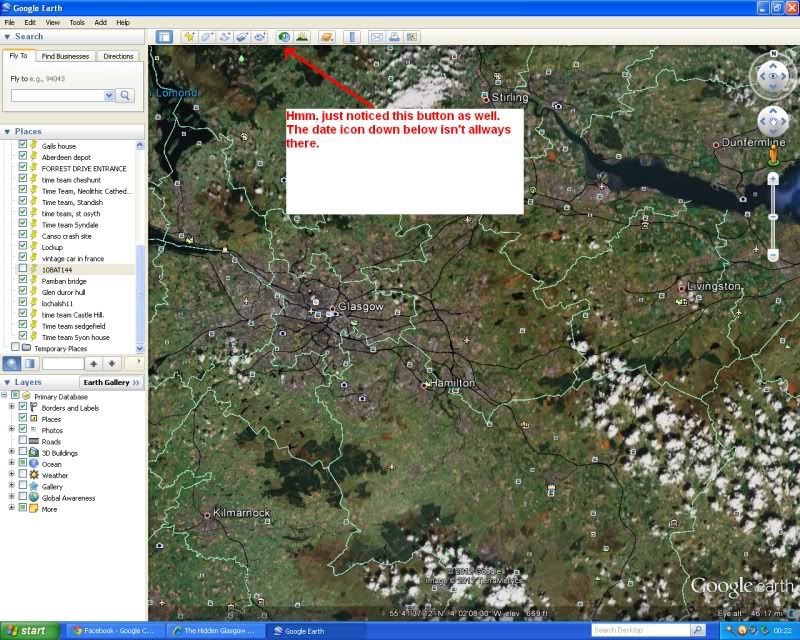
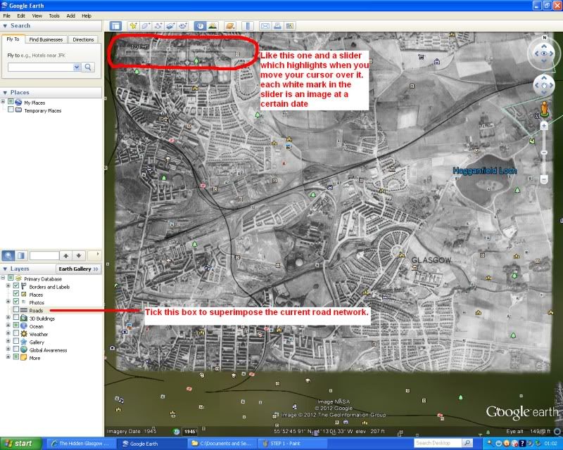
Google earth is your friend in this case. If you zoom into Port Dundas and the m8 out toward Baillieston and select the 1945 imagery you can see all of the canal that is now the M8.
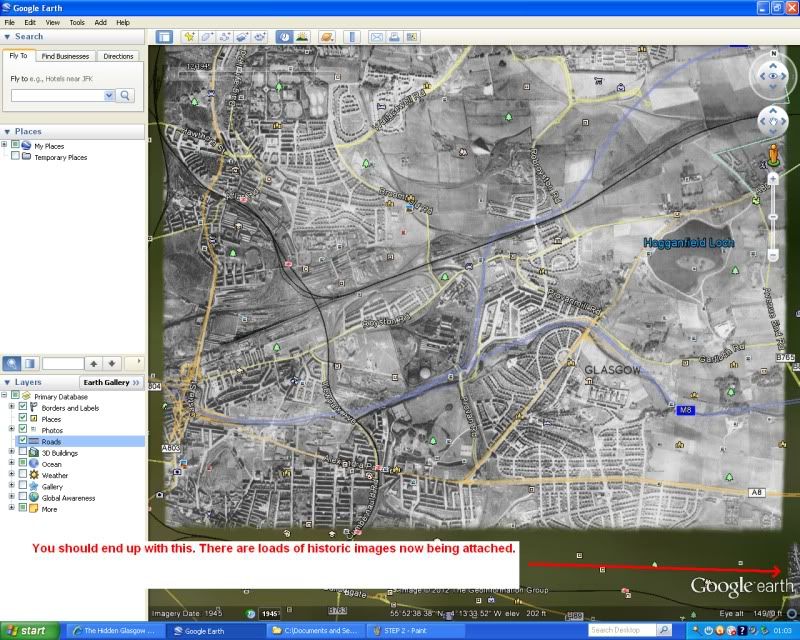
If you tick the roads box in the sidebar layers then the route of the m8 is superimposed on top of the canal. It looks like there may be a few surviving remnants of the canal next to the M8.
Would post a couple of before and after images but don't want to breach any copyright laws.
Re: Monkland Canal prior to motorway
Posted:
Sat Jun 02, 2012 10:10 amby Icecube
And the historical imagery is located where?
Re: Monkland Canal prior to motorway
Posted:
Sun Jun 03, 2012 12:48 amby Vintagebuff
Okay open Google Earth and focus on Glasgow. Something like the pic below.
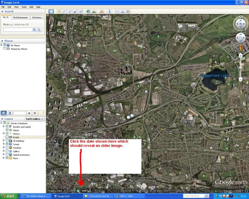
Now zoom in/out and scroll over the uk to reveal more images. The oldest I noticed so far was 1942

Trying to think of a good excuse for the unashamed breach of copyright.

Sorry.
Re: Monkland Canal prior to motorway
Posted:
Sun Jun 03, 2012 9:50 amby Josef
Cheers, vb. I hadn't noticed that option was there.
Re: Monkland Canal prior to motorway
Posted:
Sun Jun 03, 2012 6:09 pmby Vintagebuff
You're welcome. Found it by fluke myself a while ago but have spent a lot of time browsing the historic images. Being able to highlight the road network sure helps when comparing with recent images.
As you can see the Monklands canal shows up nicely :). Along with a lot of old railways and roads etc.
Re: Monkland Canal prior to motorway
Posted:
Sun Jun 03, 2012 9:16 pmby Dexter St. Clair
Thanks to Vintagebuff for the answer and a bigger thanks to Icecube for asking the question.
Re: Monkland Canal prior to motorway
Posted:
Mon Jun 04, 2012 7:42 amby Vintagebuff
Re: Monkland Canal prior to motorway
Posted:
Mon Jun 04, 2012 4:07 pmby Icecube
Thanks VB, I'm in the zone noo

A great wee tool which I will make good use of.
Re: Ruchazie Section of the Monklands Canal
Posted:
Thu Aug 22, 2013 4:24 amby weskyman
Alex Glass wrote:My family moved to Ruchazie in 1967. About 50 feet from our back garden was the Monklands Canal.
There where a number of shallow crossing points along the canal and like Frank we also made a raft to cross where the water was deeper. I remember when we first moved to Ruchazie seeing the odd barge traveling toward Cranhill. It wasn't long although then it seemed like a lifetime before the barges were withdrawn and the canal closed off to make way for the M8.
We had many adventures along the banks of the Monkland Canal and many fond memories.
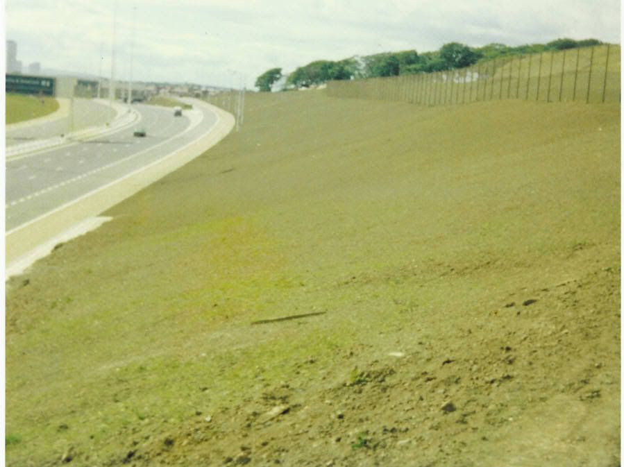
I live in Ruchazie, although only moved here 6 years ago but was really interested to see this image. So much so I decided to grab my iPhone and try to recreate the photo for 2013. Obviously I couldn't access the garden from which the original was taken but managed to climb the embankment and get pretty close. In my photo you can see the narrow footpath between the hard shoulder and the verge to compare the relative vantage points.
I didn't come across Alex's other image across the M8 towards Riddrie where the Council depot now is until after I had taken this photo so will try to recreate that shot at the weekend.
Hope you find this interesting

Re: Ruchazie section of the Monklands Canal
Posted:
Thu Aug 22, 2013 4:59 amby weskyman
Alex Glass wrote:Ok so we need to stick with private collections them. Well I will need to post this photo that includes some friends and relatives from the early 70's. That's the 1970's before anyone has a dig.
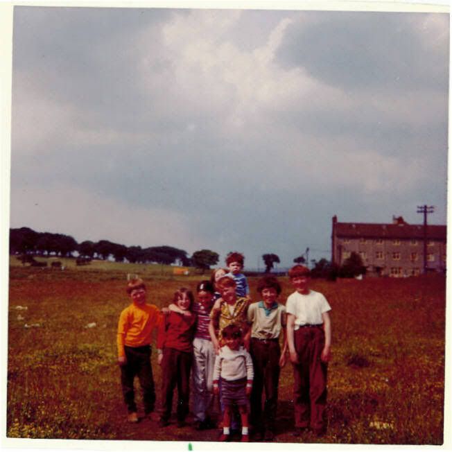
This picture was taken about 20 yards from the position of the picture above. Although taken at a different angle it shows the fields that were lost to build the M8. Unfortunately I don' think I have any pictures of the canal.
If anyone knows the location of photos on the net I would be happy to make contact and request permision form the organisation hosting the pictures to use on this site.
Alex's photo above faces north towards Gartloch Road and Lethamhill Golf Course. Interesting to see the flats on the right of the picture. There is now a sheltered housing scheme in this area blocking the view to the golf course, and the block of flats in the picture have been replaced by modern terraced housing. So the fields themselves weren't necessarily lost as a result of the motorway but of later development. The scheme seems to be very modern. I don't know when it was built but having walked through it a few times I would guess within the last decade. The chances are the land was developed prior to the building of the new houses thereby clearing the fields but I don't know.
The image below shows the housing scheme and the red arrow shows roughly the location from where I took the photo of the M8 in my previous post which should not be too far from the location of Alex's photo

Re: Monkland Canal prior to motorway
Posted:
Thu Aug 22, 2013 5:41 amby weskyman
Re: Monkland Canal prior to motorway
Posted:
Thu Aug 22, 2013 6:09 amby yoker brian
Used to play there as a kid with my cousins, when visiting my gran who lived on Croftcroign Rd - I'll ask my mother to see if she could shed any light as to what the buildings were.
Re: Monkland Canal prior to motorway
Posted:
Fri Aug 23, 2013 9:12 amby weskyman
Thanks Brian. Someone put the following comment against one of my photos on Panoromio:
britishplastering, on November 23, 2009, said:
part of an old house that was lived in at one point by auld willie the farmer there used to be cows and stuff on the land behind the trees. Sometimes they would escape and crap all over the place including the football pitches at ruchazie school.
Nice image

I'm pretty sure it was buildings to do with an old farm but any information would be welcomed
Re: Monkland Canal prior to motorway
Posted:
Fri Aug 23, 2013 11:40 amby Fat Cat
Last remnants of old Ruchazie. My sister in law livedin Croftcroighn Road and I remember her saying there was a few old houses which were old farm buildings and they'd get eggs from there. Pulled down in the 70s I think.
Re: Monkland Canal prior to motorway
Posted:
Sat Aug 31, 2013 7:32 amby browning
Hi,
As a resident of Ruchazie from 1963 to 1973 I think I can shed some light on your queeries. The remains you found were of Craigend House: according to old maps. It wasn't a farm, it was a private "house" of some kind or a "club" venue and quite sizeable:perhaps 10 or 12 rooms over at least 3 or 4 levels. My friends and I could never fathom its purpose. I'm not sure now (nearly 50 yrs later) if rugby/playing fields lay to the south between the "house" and the canal.
Set in the woods as it was, it was very spooky on dark nights. We would occasionally snoop about it ...and on being caught were firmly told to go away. We imagined it (as circa 10 yr olds) to be haunted! It was highly atmospheric during the still occasional fogs of the sixties...and great fun.
There was a farm run by "Wullie" which actually lay around 200 yds east of the "house" and he did indeed sell eggs and would happily even wring a chickens' neck for customers to "takeaway". I met him a few times on the farm with friends who knew him. What a character...think duelling banjos! (seriously).
I hope this is of interest.
Best wishes,
Browning.