Page 4 of 15

PostPosted: Thu Dec 02, 2004 3:31 pm
by james73
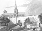
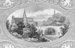
Sharon wrote:Well, Molly. (Molly works i think :wink: ) as a taster, or in case yo dont get around to it...heres a few pictures of the Molendinar it the two places it can be seen.


Isn't there a waterfall section near where Royston Road and Provanmill
Road meet? I'd assumed that this was the Molendinar burn. I don't really
want to venture up there as it's a neds playground most of the time.

*Edit* found this http://www.roystonroadproject.org/archive/molendinar_park/molendinar_park.htm


Also, there used to be a plaque on a wall next to the Alexandra Parade
to Springburn railway, just south of where the M8 passes overhead. It
said 'Site of Molendinar Burn' or something on it. Dunno if it's still there,
but I dont remember actually *seeing* the burn there.


James H

PostPosted: Thu Dec 02, 2004 3:39 pm
by Molendinar
re the redirection, the doctors have reassured me that I will only feel a slight discomfort that will pass after a few days...

PostPosted: Thu Dec 02, 2004 5:00 pm
by crusty_bint
That plaque you speak of James is still there, not far from the section they are re-direction at Armadale Path. pass it ofeten... never think to take a pikchurr tho. hey ho.

PostPosted: Thu Dec 02, 2004 7:45 pm
by Sharon
Molendinar wrote:re the redirection, the doctors have reassured me that I will only feel a slight discomfort that will pass after a few days...


:D

crusty bint wrote:That plaque you speak of James is still there, not far from the section they are re-direction at Armadale Path. pass it ofeten... never think to take a pikchurr tho. hey ho.


Now you KNOW you should always have a camera on standby!! You know what you have to do...

PostPosted: Wed Mar 30, 2005 10:08 pm
by Sharon
Its occuring to me once more that we missed out a chuck of the Molendinar when we did our walk last year, what i didn't appreciate was that there was a section of it visible - other than those at the Gt Eastern and Riddrie!!

Image
Molendinar Park - Blackhill

Might have to have a quick spin past sometime for the sake of completeness :)

I was whiling away the hours the other day on SCRAN looking for some old photos of the necropolis, of which they had suprisingly few, and kept instead getting lots of lovely engravings showing the catherdral and the necrolpolis from various angles with the Molendinar cutting through the steep steep valley.

What I hadn't realised before was that the burn had been dammed at the bridge, pretty much where there seemed to be natural falls. But the effect - depending on water levels seems to have been to create a wall of water at the bridge, which must have looked and sounded just beautiful.

It also struck me that there must either be a whole lot going on under the road - which is what i want to imagine - or a serious amount of infilling was done - leaving teh molendinar in a big pipe or something equally dull - before the road was laid out.

PostPosted: Thu Mar 31, 2005 8:17 am
by Sharon
I believe that Hogganfield Loch is its source...

PostPosted: Thu Mar 31, 2005 9:19 am
by Alchemist
Also in this vicinity were the lochs of Frankfield and Hogganfield, the two joined by an artificial cut, which was marked as "Molendinar Burn" on the Ordnance Survey maps, giving rise to a suggestion that the famous water course genuinely began at Frankfield. The late Jack House, in an article in the Glasgow Evening Citizen of 7th January 1946, dismissed this idea. He claimed that maps he had examined at the City Engineer's Department proved that Hogganfield Loch was the true source of the Molendinar. The Ordnance Survey Name Book of the 1850s described Frankfield as "Low, wet land, part in this [Cadder] parish & part in the Barony parish. This Loch is dry in summer & flooded in winter. There is not, at present, any sign of the ground being drained for cultivation". When the two lochs were frozen in winter, skaters could skate from one to the other along the "Molendinar" cut, although they had to break their momentum to cross the Avenue End Road.


I've looked at the OS map, can't see spit

:x

PostPosted: Thu Mar 31, 2005 9:25 am
by Sharon
Ah, I am mapless today so didnt check, but yeah, an artificial link between the 2 doesn't count ;)

I'm with Jack, its source is Hogganfield!

PostPosted: Thu Mar 31, 2005 9:28 am
by Alchemist
There must be a fair amount of it piped under the
city. Looking a the map, I can hardly see a thing.

PostPosted: Thu Mar 31, 2005 9:37 am
by Sharon
Apart from what turns out to be 3 spots where its allowed to see the light of day before it spews out into the Clyde... theres a whole lot going on under the streets.

PostPosted: Thu Mar 31, 2005 9:49 am
by Alchemist
Molendinar residents spent 2 week holiday at Indian temple

Image

PostPosted: Thu Mar 31, 2005 11:58 am
by Sharon
Hmm.... I'll consider conceding this one :wink:

So theres a "natural" source and a ... "actual" source... how does that sound?

PostPosted: Thu Mar 31, 2005 3:29 pm
by Sharon
The pictures of teh Molendinar that caught m eye.

First teh falls.

Image

Secondly the wall just behind the main arch. Or the dam.

Image

And finally a wall of water tumbling over this dam.

Image

I've paid the subscription to SCRAN so have seen these bigger. Mustv been a pretty lovely spot when it was all damned up.

PostPosted: Thu Mar 31, 2005 3:31 pm
by Sharon
And yes, a wee look at that end of Hogganfield is definately required. Just for the sake of clarity.

PostPosted: Thu Mar 31, 2005 7:48 pm
by crusty_bint
My bus used to pass this when i lived in Garthamlock. Its just a small, linear cutting, maybe 2 foot wide and 3 or 4 foot deep, which emerges from under Avenue End Rd on a roughly east/west alignment. The cutting itslef was made as a drainage ditch for the surrounding playing fields (owned by Strathclyde University) which was a bog if you have a look at older maps, or even the neighbouring field in Craigend. The cutting doesnt have an actual physical link to Frankfield Loch, but comes close enough so that any overspill or run-off from Frankfield and neighbouring landscape ends up in Hogganfield Loch via the cutting. So I spose, technically, in view of the topography, I suppose Frankfield Loch is the source of "Huggie" ...never actually thought about it before :D

as illustrated....
Image