The Hidden Glasgow Forums
To post in the forums you will need to first register. All new members are welcomed, with one caveat: You must behave and be nice AND SEARCH BEFORE POSTING!
Molendinar Burn
Moderators: John, Sharon, Fossil, Lucky Poet, crusty_bint, Jazza, dazza
Re: Molendinar Burn
![]() by Ronnie » Fri Jul 10, 2009 4:22 pm
by Ronnie » Fri Jul 10, 2009 4:22 pm
-

Ronnie - Third Stripe

- Posts: 1983
- Joined: Sat Jan 17, 2004 11:22 pm
- Location: Glasgow
Re: Molendinar Burn
![]() by D17AVD » Fri Jul 10, 2009 5:00 pm
by D17AVD » Fri Jul 10, 2009 5:00 pm
- D17AVD
- Busy bunny

- Posts: 14
- Joined: Sun Jul 05, 2009 11:49 pm
Re: Molendinar Burn
![]() by Mori » Fri Jul 10, 2009 5:52 pm
by Mori » Fri Jul 10, 2009 5:52 pm
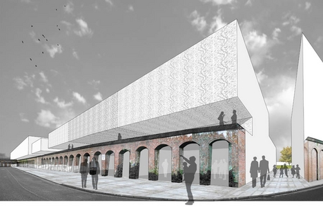
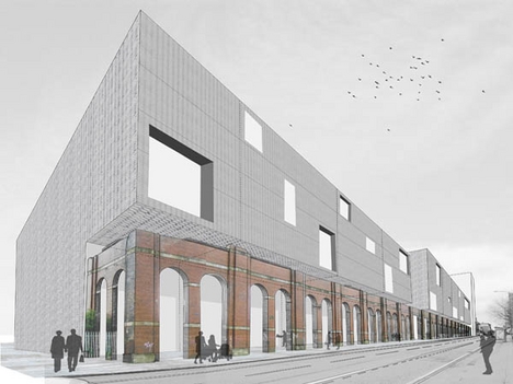
A Uni students thesis on the High, Duke St area around Collegelands.
The masterplan seeks to re-orientate Glasgow’s High Street as the city’s cultural axis. A museum quarter and new public park will be become the centre of the Masterplan.
This area will be created around a revealed Molindinar burn, returning that area to its original topography. The Molindinar burn has great cultural significance as the city was originally formed along its course. The new cultural area will connect Glasgow Green to the Necropolis in the north and regenerate the Barras market to the south.
Fragment of walls remain in the area from the former Goods Yard. These will be retained and used in the Masterplan. The proposed urban grain re-introduces a “herring-bone” structure to Glasgow’s High Street. This strip typology references the wall fragments surrounding and creates smaller streets typical of a High Street, giving the area a distinct character and sense of place.
Small canals will channel all surface water into the Molindinar burn and further down to the River Clyde. Two former Hydraulic Pumping Stations will be re-introduced at either end of the park area on the burn, this will power all lighting throughout the park and become entrance markers from the East and West.

-

Mori - Third Stripe
- Posts: 3434
- Joined: Wed May 04, 2005 1:05 pm
- Location: Glasgow
Re: Molendinar Burn
![]() by Glesga_Steve » Fri Jul 10, 2009 7:13 pm
by Glesga_Steve » Fri Jul 10, 2009 7:13 pm
Ronnie wrote:Brilliant work, guys. Now, for the money shot ... where exactly does the Molendinar dischage into the Clyde? And if it's not the tunnel mouth on the quay immediately south of the High Court complex, then what's that one? Thanks.
I thought the anwer to this question had already been made clear in previous posts...
The "tunnel mouth" immediately to the south of the High Court buildings is the original outfall/discharge point of the Molendinar Burn. I know from having been inside the "tunnel mouth" many years ago that this old section of culvert is bricked up about 30 feet "upstream" (underneath Clyde Street).
The Molendinar Burn culvert was diverted a LONG time ago to its current outfall/discharge point at the western corner of Glasgow Green, immediately downstream of the tidal weir.
The pre-diversion route of the Molendinar Burn was from the junction of Turnbull Street/Greendyke Street, along Greendyke Street, across High Street into Jocelyn Square until the junction of Jocelyn Square/Mart Street, down Mart Street, across Clyde Street and into the river.
I've always assumed that the culvert was diverted for High Court security reasons (e.g. to stop 'undesirables' from going up the culvert and blowing it up underneath the High Court buildings).
-

Glesga_Steve - Third Stripe
- Posts: 674
- Joined: Sat Mar 14, 2009 12:46 am
Re: Molendinar Burn
![]() by BenCooper » Sun Jul 12, 2009 5:22 pm
by BenCooper » Sun Jul 12, 2009 5:22 pm
D17AVD wrote:...The entire eastern bank is now built up with cages full of rocks, to a height of at least 6" above the burn level...
Those have always been there - it's a wee bit of a climb or jump down, but not too bad.
- BenCooper
- Second Stripe

- Posts: 183
- Joined: Mon May 26, 2008 4:06 pm
Re: Molendinar Burn
![]() by jonno22 » Mon Jul 13, 2009 9:46 am
by jonno22 » Mon Jul 13, 2009 9:46 am
BenCooper wrote:D17AVD wrote:...The entire eastern bank is now built up with cages full of rocks, to a height of at least 6" above the burn level...
Those have always been there - it's a wee bit of a climb or jump down, but not too bad.
If you have good determination then jump it down to the burn. I think it would be worth it. I saw Ben's pics and they were excellent even the one of the rat posing for the camera mor or less haha. Is there many rats down there Ben because if there is it is a no no exploration for myself. I saw one at Clydebank train station the other day while waitng for my train home and it was disgusting. It must have been about 3ft long - IT WAS MASSIVE!
Best Regards
Jonathan McGurk
Railway and Freelance Photographer
www.jonathanmcgurk.fotopic.net
- jonno22
- Second Stripe
- Posts: 150
- Joined: Sat May 02, 2009 7:19 pm
- Location: Yoker, Glasgow
Re: Molendinar Burn
![]() by toomse » Mon Jul 13, 2009 2:13 pm
by toomse » Mon Jul 13, 2009 2:13 pm


bit of a dilemma here as to what route to follow next

-

toomse - Second Stripe
- Posts: 249
- Joined: Wed Nov 19, 2008 3:52 pm
Re: Molendinar Burn
![]() by toomse » Mon Jul 13, 2009 2:25 pm
by toomse » Mon Jul 13, 2009 2:25 pm


-
toomse - Second Stripe
- Posts: 249
- Joined: Wed Nov 19, 2008 3:52 pm
Re: Molendinar Burn
![]() by toomse » Mon Jul 13, 2009 2:33 pm
by toomse » Mon Jul 13, 2009 2:33 pm


-
toomse - Second Stripe
- Posts: 249
- Joined: Wed Nov 19, 2008 3:52 pm
Re: Molendinar Burn
![]() by BenCooper » Mon Jul 13, 2009 5:15 pm
by BenCooper » Mon Jul 13, 2009 5:15 pm
jonno22 wrote:Is there many rats down there Ben because if there is it is a no no exploration for myself.
I saw about half a dozen.
A much more serious concern is that it's a very enclosed tunnel with no downstream outlet...
- BenCooper
- Second Stripe
- Posts: 183
- Joined: Mon May 26, 2008 4:06 pm
Re: Molendinar Burn
![]() by Glesga_Steve » Mon Jul 13, 2009 7:14 pm
by Glesga_Steve » Mon Jul 13, 2009 7:14 pm
toomse wrote:here’s the north east route from the fork at Duke Street
The burn that runs from the Duke Street railway bridge in a generally north-easterly direction (heading upstream) to the Gartcraig Rd Council (Roads Dept.) depot is the Carntyne Burn.
The entire burn is culverted, though there was talk a while back of changing the section at Hogarth Park back into open burn.
-
Glesga_Steve - Third Stripe
- Posts: 674
- Joined: Sat Mar 14, 2009 12:46 am
Re: Molendinar Burn
![]() by Glesga_Steve » Mon Jul 13, 2009 7:21 pm
by Glesga_Steve » Mon Jul 13, 2009 7:21 pm
toomse wrote:here’s the south east route from the fork at Duke Street
The Camlachie Burn culvert actually extends several hundred yards beyond this point.
I had it surveyed years ago and we managed to trace it up as far as the south-east corner of Easthall Primary School's football pitch.
-
Glesga_Steve - Third Stripe
- Posts: 674
- Joined: Sat Mar 14, 2009 12:46 am
Re: Molendinar Burn
![]() by toomse » Tue Jul 14, 2009 9:55 am
by toomse » Tue Jul 14, 2009 9:55 am


there is what appears to be the route of another burn 700m+ east of Easthall Primary

it looks like it’s sourced from Craigend Wood north of St Benedict’s Church and runs to Easterhouse Station


-
toomse - Second Stripe
- Posts: 249
- Joined: Wed Nov 19, 2008 3:52 pm
Re: Molendinar Burn
![]() by Glesga_Steve » Tue Jul 14, 2009 12:57 pm
by Glesga_Steve » Tue Jul 14, 2009 12:57 pm
toomse wrote:there’s nothing recorded on the route from Langbar Crescent/Delny Place to Easthall Primary School or around the general vicinity
There's nothing recorded on our GIS but that doesn't mean the culvert isn't there.
The culvert runs along the southern boundary of Langbar Crescent (on the grass verge side of the fence), follows it round parallel to Wellhouse Road and then crosses the road into Easthall Primary School. If you take a trip out there you'll notice there are large heavy duty rectangular manhole covers along this route that are not shown on our GIS - they are on the culvert. I know this because I traced the line for work purposes many years ago (before we had GIS and everything was recorded on paper plans).
If you zoom into the school, you'll notice a small surface water sewer is shown running along the embankment to the south of the football pitch - this is in fact, the top of the Camlachie Burn culvert.
I should get all this updated but it's not exactly top priority as the culvert isn't our (Scottish Water) asset.
-
Glesga_Steve - Third Stripe
- Posts: 674
- Joined: Sat Mar 14, 2009 12:46 am
Re: Molendinar Burn
![]() by Glesga_Steve » Tue Jul 14, 2009 1:09 pm
by Glesga_Steve » Tue Jul 14, 2009 1:09 pm
toomse wrote:
there is what appears to be the route of another burn 700m+ east of Easthall Primary
it looks like it’s sourced from Craigend Wood north of St Benedict’s Church and runs to Easterhouse Station
You are correct, there is another (unnamed) burn there in culverted form.
It opens into a short section adjacent to Whamflet Avenue and the goes back into culvert and joins the Tollcross Burn on the west side of Easterhouse Road.
The two blue lines shown running east-west on the last plan you uploaded are in fact the Monland Canal pipeline and the Baillieston Surface Water Sewer (this mainly drains the M8 from Jimmy Young's bridge to The Fort).
I'll upload a plan later tonight with some added annotiation to show this area.
-
Glesga_Steve - Third Stripe
- Posts: 674
- Joined: Sat Mar 14, 2009 12:46 am
Return to Hidden Glasgow Projects
Who is online
Users browsing this forum: No registered users and 8 guests